Costa Rica’s Big Sur: How Geography Shaped the Costa Ballena
From remote surfing villages to thriving coastal communities, mountains, rainforest and the Pacific Ocean have shaped a remarkable place to visit—and to call home.
By Scott Bowers

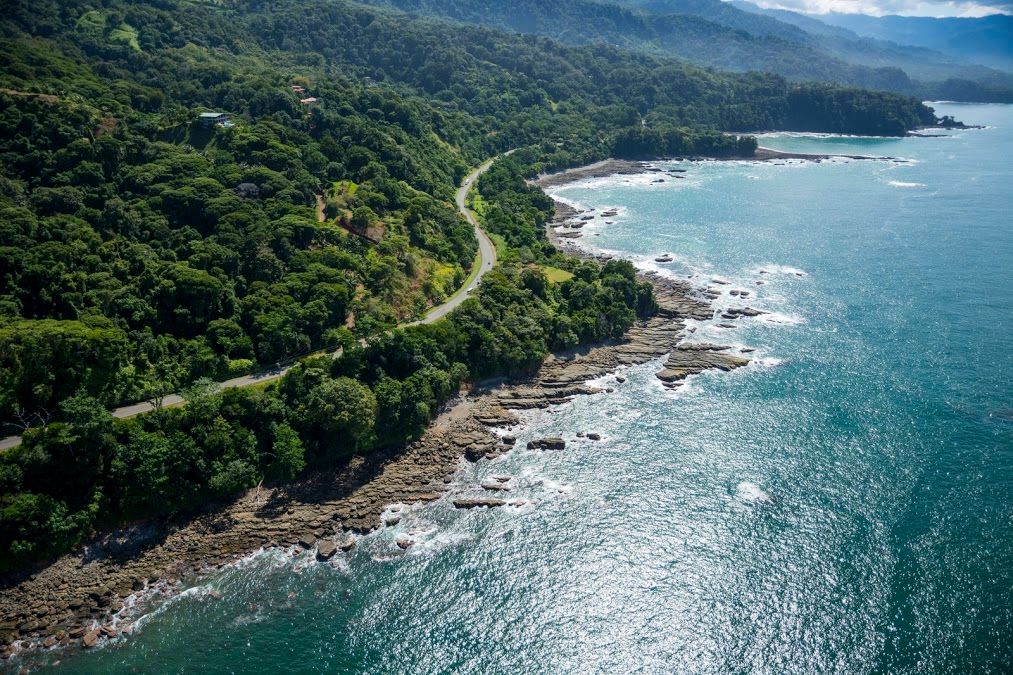
Punta Uvita, where the coastline’s distinctive shape is best appreciated from above. Photo: Mario Roberto Durán Ortiz / Wikimedia Commons, CC BY-SA 4.0.
There’s something special about Costa Rica’s southern Pacific coastline, aka, the "Costa Ballena."
Here, lush green mountains rise above the ocean, tropical forests stretch toward the beaches, and coastal communities combine extraordinary natural beauty with an increasingly impressive range of everyday conveniences.
You can spend your morning walking along a Pacific beach, stop for coffee at a local café, enjoy lunch at an excellent restaurant, and finish the day watching the sunset. In communities like Uvita, that lifestyle is very much part of the region’s appeal.
Venture a short distance inland, and another side of the Costa Ballena comes into view: hillside homes overlooking the Pacific, forested properties alive with birds and monkeys, and places where privacy and open space are as much a part of the attraction as proximity to the beach.
I’ve sometimes described this stretch of coastline as Costa Rica’s version of Big Sur, the spectacular region along California’s Pacific coast where mountains rise dramatically above the ocean.
The comparison is about the landscape. Our tropical climate, rainforest and communities have their own distinct character. But that meeting of mountains and ocean creates a similar sense of drama—and helps explain why development here has followed a different path.
 |  |
| Big Sur, California | Costa Ballena, Costa Rica |
Big Sur photo: Joseph Plotz, with color correction by Dpalma01 / Wikimedia Commons, CC BY-SA 3.0.
When Getting Here Was Part of the Adventure
When I first arrived in Costa Rica in 2001, the Southern Zone was a very different place. One of the biggest obstacles was simply getting here.
The stretch of the Costanera between Quepos and Dominical was still a notoriously rough dirt road. That journey of roughly 42 kilometers could sometimes take close to two hours. I remember the paved road from Dominical up to San Isidro de El General, too: riddled with potholes and badly in need of maintenance.
Traveling around this part of the country required patience, a sense of adventure and preferably a sturdy vehicle.
Dominical already had a following among surfers drawn to its powerful waves, but it was a small, rustic beach community. Uvita was a little rural town surrounded by extensive greenery, and Ojochal was a quiet community with far fewer of the businesses and services people enjoy today.
The natural beauty was always there. Convenient access was another matter.
Completion of the paved Quepos–Dominical connection in 2010 helped change that. Suddenly, reaching this coastline from the Central Pacific was much easier. A destination that had once demanded considerable effort became accessible to a much wider range of travelers.
Tourism expanded, businesses followed, and more visitors began imagining a life here.
Once a place gets onto the tourist radar, the expats follow. That has certainly been part of the Costa Ballena’s story.
Over the years, I’ve watched Uvita grow into a bustling commercial and residential center. Ojochal has become an established international community with a remarkable dining scene. Dominical has expanded its restaurants, shops and accommodations while retaining its surfing identity.
The region has changed enormously. But the geography that shaped it is still here.
The Lay of the Land
To understand the Costa Ballena, it helps to picture southern Costa Rica in layers.
Inland, the towering Talamancas form the country’s great mountain backbone. Between those high mountains and the Pacific lies the Valle de El General, home to San Isidro de El General and much of Pérez Zeledón. Closer to the ocean, the coastal mountain system—including the Fila Costeña—creates the ridgelines and hillsides that overlook the Dominical–Uvita–Ojochal corridor.
These are distinct landscapes. The hills immediately above the beach are part of the coastal range; the much higher Talamancas rise farther inland.
Along much of the Costa Ballena, the coastal hills leave a relatively narrow strip of level ground between the mountains and the ocean. Uvita has one of the region’s most useful concentrations of flatter land, often called the “Uvita flats,” although smaller lowland pockets exist elsewhere.
That distinction matters when people begin looking for a home. There are properties within walking distance of the beach, but the choices are concentrated in particular neighborhoods. Many of the region’s most dramatic ocean-view homes sit up in the hills.
Why the Landscape Slows Development
Building on a mountainside is a different proposition from building on a broad, flat coastal plain.
Roads have to negotiate slopes. Building sites require careful planning. Drainage, erosion control, retaining structures and utility connections can add substantially to the work and expense involved.
A beautiful tract of land may contain far less usable building area than its total acreage suggests. That is something I regularly explain to buyers: the size of a property and the amount of land you can comfortably use are two different things.
Geography also interacts with environmental protections. Forest cover, waterways, springs, mangroves and protected areas can affect where and how construction is possible. The Fila Costeña is not one uniformly protected parcel, but development on its hillsides must take the conditions and restrictions of each property into account.
Along the shore, coastal land rules add another layer. Costa Rica’s maritime zone generally extends 200 meters inland from the ordinary high-tide line, with the first 50 meters designated as the public zone and the next 150 as the restricted zone. Concessions, legally recognized title exceptions and protected areas make the situation more complex than simply assuming every coastal lot is ordinary private property.
Marino Ballena National Park protects important stretches of this coastline, including beaches around Uvita and farther south. Those protected shores contribute enormously to the area’s appeal, while placing limits on development.
Even a titled property near an estuary may have environmental restrictions. A title answers an ownership question; it does not, by itself, establish what can be built.
A Real Estate Market Shaped by the Hills
These conditions have helped produce a market with its own character.
Alongside homes in the coastal communities, the Costa Ballena offers hillside residences, private estates and rainforest properties with sweeping Pacific views. In many cases, the attraction is the combination of an ocean outlook, surrounding greenery and space between neighbors.
Elevation and exposure may provide welcome breezes, although a hillside address does not automatically mean a cool climate. Access roads, travel times and maintenance needs vary considerably.
The Uvita flats offer a different set of advantages: gentler terrain and, in some neighborhoods, easier access to shops, restaurants and park entrances. They can be a good starting point for buyers whose priority is walking to the beach.
But “near the beach” and “an easy walk to the beach” deserve separate attention. The actual route, highway crossings, shade and the location of a legal access point matter. Where access is through a national park, entry rules and opening hours matter as well.
Neither hillside living nor life on the flats is universally better. The question is which setting fits the way you want to spend your days.
The Rain Is Part of the Beauty
Another defining feature is the rain.
The southern Pacific generally experiences a wetter climate and a longer rainy season than the drier northwestern Pacific. There is a drier season here, too, but the landscape typically retains a lushness that many people immediately associate with their idea of tropical Costa Rica.
That moisture sustains the forests, rivers, gardens and waterfalls that make the region so appealing. It also makes drainage, ventilation, road conditions and regular property maintenance important parts of daily life.
When buyers fall in love with all that greenery, I remind them that the rainfall is part of the package. Understanding both sides helps people choose a home they will enjoy throughout the year.
What Happens as the Region Continues to Grow?
Improved access and growing popularity have brought real change. The Costa Ballena is an established destination, and its communities will continue to face questions about how to accommodate growth.
The practical limits of the landscape remain. Large projects must fit the terrain, available water and infrastructure, and the environmental and permitting requirements that apply to their location.
Multi-unit development introduces additional demands. What can be approved depends on the property and the proposed project; it is not safe to assume that something built nearby can simply be repeated on another site.
My view is that these constraints will continue to influence the pace and form of development. They do not guarantee that every property will appreciate, or that the coastline will remain unchanged. But they help explain why growth here is more complicated than drawing a subdivision across a flat field.
Preserving the landscape while providing reliable services for a growing population is part of the region’s next chapter.
Pérez Zeledón - A Cooler Alternative Just Inland
The Costa Ballena is the focus here, but it is worth looking over the coastal range at Pérez Zeledón.
For people who love southern Costa Rica but prefer a cooler setting, the higher-elevation communities around San Isidro de El General offer another appealing way to live. Temperatures vary with altitude, so choosing the right elevation is part of finding the right fit.
Many expats are drawn to the greater space and less concentrated development available in the surrounding countryside, with mountain views and a strong connection to everyday Costa Rican life.
San Isidro is a substantial regional city, providing shopping, health care, professional services and the practical conveniences that make rural living easier. Beyond the city, the communities retain a distinctly local, Tico character.
You trade walking to the beach for a mountain lifestyle, with the coast still within reach for outings. For some buyers, that combination is exactly what they were hoping to find.
Why the Costa Ballena Feels Different
The mountains that complicate construction also create those extraordinary ocean views. The rainfall that demands maintenance sustains the greenery. The protected shores and forests that limit development preserve much of the beauty that brings people here.
Meanwhile, the communities have evolved. You can enjoy good restaurants, cafés and modern conveniences, then return to a home surrounded by tropical forest. Or you can choose a neighborhood closer to the beach and make the shoreline part of your daily routine.
For me, that is the appeal of Costa Rica’s Big Sur: the meeting of mountains and ocean, with communities that have grown around the landscape.
After watching this region change over the past quarter century, I still find that combination remarkable.
Thinking about making southern Costa Rica your home? I help buyers explore the Costa Ballena and Pérez Zeledón, understand the differences between communities, and find properties that fit their priorities. The best starting point is a conversation about the life you want to build here.
Background Sources
Road history: La Nación, “Concluida última fase de carretera Costanera sur,” April 30, 2010. Early travel conditions and community observations are the author’s recollections.
Coastal protections: Costa Rica’s Maritime Zone Law, Law 6043; SINAC, Parque Nacional Marino Ballena; PGR-C-240-2023, coastal estuaries and mangroves.
Photographs are credited individually above and used under their linked Creative Commons licenses. Images are displayed proportionally without additional edits.